
I left the house just after 9:30am. I was in no rush to get away today as it was rainy and cool. Arrived at Canoe Lake just after 10:30am and obtained my permit. Unloaded the canoe and gear from the truck then loaded up the canoe and was on my way by 11:15. The rain had subsided to a mist but the wind coming out of the north was strong and cold with the temperature dropping through the day to 5°C. The lake had big waves and whitecaps but thankfully I wasn’t headed up the lake. Instead I was headed to the southwest section of the lake to the Sam Lake portage.
 |
| Ready to leave from Canoe Lake on a cold, rainy day. |
Less than a half hour
later had me there. I loaded up and was
on my way over the 455m portage. Over it
in no time I was off across Sam. On Jeff
McMurtrie’s map it notes that you can skip the 110m portage into Gill
Lake. Heading around the point to the
west I pulled over a shallow beaver dam and was soon into Gill Lake. Across it I went to my biggest portage of the
day, an 1850m into Drummer Lake. The
portage was good but a good flowing stream crossed the trail three times
leaving me no choice but to wade through them.
So much for trying to keep my feet dry as long as possible.
Twenty-five minutes brought me to Drummer Lake and to the
little lean-to shelter that I had forgotten was there. It was nice to have it as the rain had
started back up and was coming down pretty good. I had a snack and waited out the rain. Fifteen minutes later it had subsided enough
that I decided to head out. Drummer has
two campsites on it, both of which looked half decent from the distance.
 |
| Drummer Lake shelter hut. |
I paddled through Little Drummer and the lone site there
looked nice as well. The portage to Tonakela
was signed but the one to Namakootchie, my next destination wasn’t, but it was
easy enough to pick out the trailhead.
Over the 790m portage into Namakootchie I headed up the lake
with a nice tailwind. The only good
thing about the north wind today was that I could count on a tail wind on most
of the lakes.
From Namakootchie a 685m portage took me into Ramona, a
non-descript little lake with four backpacking sites on it but I couldn’t see
any evidence of them from the lake.
Out of Ramona a 1065m took me into Dace Lake. The portage was good, following the
backpacking trail for awhile before veering off towards the lake on a wicked
downhill. I don’t think I’d want to be
coming the other way on this portage.
Once into Dace I took a side trip walking the portage into Panther. I had been through Panther before but only
through the north end through Mossy and Thunder.
After a nice little walk I headed off down Dace and decided
to have lunch when I reached EU Lake. A
415m portage took me to a little pond and a short paddle across it almost
brought me to the 125m portage to EU Lake.
At the end of the pond were two beaver dams that I had to pull over to
get to the portage. I pulled over the
first one and then went about ten feet before having to pull over the second
one. The portage definitely needs to be
re-routed to start before these dams.
 |
| Beaver dams at end of Pond before EU Lake Portage. |
A short carry had me at EU Lake on the small creek that
feeds into it. I sat on a rock and had
my lunch and was on my way again around 3:40pm.
EU is a nice little lake and as I passed through the narrows into
Whitespruce Lake I noticed the 1005m portage into Oak which I would be doing
tomorrow. I paddled down Minnow to the
end of the lake to the 1125m portage into Maggie Lake, my destination for the
day. The portage was good, the first
half skirting some mud flats and the second half being a good uphill climb
before levelling out at Maggie.
The time was 4:45pm and the wind was still howling from the
north and thankfully the rain had stopped awhile ago. There were only two canoe sites on the lake,
both on the main island. There were also
several backpacking sites scattered around the lake. I was hoping one of the two island sites
would offer some good shelter from the wind.
The site on the east end of the island wasn’t very good and
didn’t offer much shelter. I paddled
around the island but couldn’t find the site on the west end. Not wanting to take a backpacking site in the
off chance someone did come along that needed a backpacking site I resigned to
take the site at the other end of the island.
I set up camp quickly and then went about looking for
firewood. While there was enough wood
about it was all pretty soaked from the rain and coupled with the wind I knew
my chances were slim to none that I’d be able to coax a flame out of the wet
wood. I tried several times using some
paper, Kleenex and wood shavings and was able to get a small flame started but
the wet wood just wouldn’t catch.
Giving up on the fire I got dinner ready and had some
chicken fajitas and rice and coffee.
With dinner over and no hopes of getting a fire going, the temperature
falling and a light rain picking up, I hung the food pack and retired to the
tent at 8pm. I read for about an hour
then went out for a pee before calling it a night. The light rain had turned to light snow. It was suppose to go down to 0°C s I wasn’t
surprised to see it, just not what you’d expect for May 23rd! I climbed into my sleeping bag, cinched it up hoping to stay
warm through the night and that tomorrow would bring better weather.
Friday, May 24 – Day
2
Awoke at 6:30am. I
had a fairly good night’s sleep and stayed warm enough. At some point I had a thought on how to get a
fire going, use some stove fuel. So I
pilled on the tinder and kindling and poured on a bit of fuel. It actually worked! It took awhile for the fire to grow in size
but by the end of breakfast I had a good fire going and was warming up my
neoprene socks and hiking shoes
.
I broke camp after breakfast. The wind had kept up all night and was still
going. It looked like I’d be having some
head winds today. It was still cloudy
but was supposed to get sunny later in the day and be slightly warmer with a
high of 12°C.
Bundled up and packed up I was on the water at 8:30am. I retraced my route from yesterday back to
the 1005m portage to Oak Lake. As I was
unloading the canoe I looked back down Whitespruce Lake and saw a moose
swimming across the narrow section of the lake.
Where it was swimming to was a rock face so it had to swim parallel to
it towards me until it finally found a spot it could get out.
 |
| Trying to find a way out of Whitespruce Lake. |
I loaded up and was on my way. The portage was pretty good and 20 minutes
later I was at Oak and on my way across it to the 465m portage into Telma
Lake. Jeff McMurtrie had advised me that
the portage was to the right of the point unlike shown on the map, even though
there was a nice clear path and landing where the map showed.
I found the portage to the right side of the point but there
was a large tree across the landing about three feet out from shore and
suspended about a foot above the water.
There were also a few trees across the path about 20 feet into the
portage.
 |
| Oak to Telma Lake portage landing. |
I managed to get the pack and canoe over the tree on the
water and hauled everything past the jumble of trees on the path. I was then shortly on my way. The portage was the worst I had encountered
so far with trees down and the trail was fairly overgrown. Right near the end of the portage I lost the
trail. Seeing the lake to my left about
30 metres away and what looked like a path, I headed down to the lake to what
looked like a rough landing, but there was no sign. I loaded up and started off and about 10
metres from where I put in was the actual portage landing.
 |
| Start of Oak to Telma Lake portage. |
A really brief paddle had me at the 55m portage into Mossy
Lake. Mossy is a nice lake and the lone
site at the east end seemed decent.
From Mossy I took the 355m portage into West Harry. The portage is a good one and passed over a
picturesque stream a couple of times.
There is a steep downhill towards the end which I wouldn’t want to do in
the other direction.
 |
| Stream on Mossy to West Harry portage. |
From West Harry I was to head towards the 1415m portage to a
pond but instead I was first going to do a little side loop down to Lupus and
over to Red Lake. I had been through the
surrounding area before but hadn’t been through Lupus or the portage to Red so
I wanted to do the side loop to add to my route map.
It was a nice paddle with a tail wind going down West
Harry. The loop added an extra two hours
to my day. I reached the 1415m portage
just before 2pm and had lunch there and checked out the old dam. I was on my way about 2:15 and 25 minutes
later I was at the little pond at the end of the portage.
 |
| Old dam at end of West Harry Lake. |
I skirted around the right shore of the pond following the
plastic portage markers as I looked for the landing of my next portage. I thought I had found it as the marker on one
tree pointed left and the marker on a tree to the left pointed right so I
thought the landing was in between. I
unloaded and was on my way up what looked like a trail but turned out not to be
one. I tried a different trail but it
wasn’t the one either. Then I tried a
third with the same results. The portage
was only 135m and Floss Lake was on the other side of the ridge so I just
barrelled ahead a bushwhacked it. I was
soon at Floss and ended up about 20 metres from the actual portage
landing. I walked the portage back and
saw that I had missed the actual landing by about 30 metres.
I was where I was suppose to be so I loaded up and was off
across Floss to the 875m portage into another pond. The portage posed no problems and the pond
was picturesque. From the pond was my
last portage of the day, a 355m into Clara Lake, and my camp for the
night. I had done this portage a few
years ago and at the Clara end there is a swamp with a rotted out
boardwalk. Then I had slipped off it and
ended up to my knees in much with a pack on.
I’d have to make sure I didn’t do the same thing this time.
The boardwalk still hadn’t been replaced but this time I
made it across without incident. I
finished the portage at 4:30pm and by 4:45 I was on my site on Clara. It is a nice high, rocky site with a great
western view of the lake. It was fairly
well sheltered from the wind but it only had one place for a tents and even
that wasn’t big. I couldn’t see anything
bigger than a two man tent going in there.
 |
| Clara Lake campsite. |
 |
| Clara Lake campsite. |
I set up camp then went out for a short paddle down the
shore to get some fire wood. I returned
shortly with a good load that would do me for the evening and the morning.
Someone had left a couple of small camp chairs so I took one
to the top of the site and enjoyed the late afternoon sun which had finally
appeared a couple of hours ago. After
relaxing for awhile I got dinner going and had a coffee while it cooked. After a hearty dinner of Chilli Mac with Beef
I relaxed a bit more and took some pictures.
Around 9pm I got a fire going and enjoyed it until about
10pm when I retired and read for a half hour before calling it a day.
 |
| Campfire on Clara Lake. |
Saturday, May 25 –
Day 3
Boy was it cold last night!
It was supposed to be 2°C but it felt colder than the night before which
was supposed to be only zero. I awoke a
few times chilled wondering what the actual temperature was. I was awake and up just after 6am. I put water on for coffee and breakfast while
I broke camp and got a good fire going to warm me up. I enjoyed a good cup of coffee by the fire
while breakfast cooked and then enjoyed freeze dried scrambled eggs and bacon. After breakfast I had another coffee while I
continued to enjoy the warmth of the fire.
After breakfast I cleaned up and continued to break
camp. I was loaded up and on my way in
the sunshine just after 8am. It was
still cool with the wind coming out of the north but it was suppose to reach
16°C today.
The first portage of the day, a 430m into McCormack Lake,
was a short paddle away. It was a good
portage but I don’t know if I’d called McCormack a lake, more of a pond. The water level had dropped significantly and
I had to walk and extra 50m from the portage landing out to where there was
water. A short paddle across the “lake”
brought me to a narrow stream. According
to the map you were suppose to paddle right into Cashel Lake. Instead I had to pull the canoe as far as I
could up this little stream then portage over a set of shallow, rocky rapids,
then continued portaging along the shallow streambed and over a beaver dam and
finally into Cashel lake. I’d really
hate to see what McCormack Lake is like in the summer during low water
conditions!
 |
| McCormack "Lake" from the Clara Lake portage landing. |
 |
| Creek flowing out of McCormackLake to Cashel Lake. |
From Cashel, which is a nice little lake, it was a short
paddle to the 680m portage to Pincher Lake.
It was a good portage and Pincher is a nice little lake with several
backpacking sites on it but no canoe sites.
The 815m out of Pincher took me into Tern which is another
nice little lake but it had really low water levels as well. I paddled across it and tried to find the
lone campsite on it which was reportedly unlocateable. I found where it should, or use to have been,
but it was all overgrown, the sign was missing and the fire pit was just a
jumble of a few rocks. It was a shame as
it was a nice spot for a site and Tern is a pretty little lake.
 |
| Tern Lake campsite. |
After checking out the site I was back in the canoe heading
up the little river between Tern and Lady-slipper. I had heard that if the water was too low the
edge of the river would have to be walked to Lady-slipper. Fortunately the water level was high enough
to allow the canoe to pass but I could see how it could become a problem in
lower water conditions.
A short paddle up the river brought me into
Lady-slipper. Before starting the big
portage into Potter Creek I wanted to head into West Otterpaw to add that
little section to my route coverage map.
I headed to the south end of the lake to where the portage to Gervais
Lake was supposed to be. I couldn’t see
any indication as to where it was located so I walked westward a bit along the
shore. Not seeing it I headed back east
a bit. I then cut inland about 50 metres
and then headed east. I knew the portage
followed the backpacking trail so I figured if I found that then I could
backtrack and find the portage head.
Twenty metres from where I started I found the trail. I headed back down, grabbed the pack and
canoe and was off down the 310m portage to Gervais Lake.
I came to a point in the trail where I could see the lake
but the trail veered away from it and climbed up to a ridge. Not seeing a trail down to the lake I
continued along the clear path. As I
walked along the ridge and could see the lake below me I knew I’d gone too
far. Backtracking to where I first saw
the lake I looked for a trail down to it but couldn’t see one. As it wasn’t too far away I just bushwhacked
down to the lake which was pretty easy going.
Finally out onto Gervais I looked for a portage sign but I
couldn’t find one. I then headed down
the lake to the 150m portage to West Otterpaw Lake. I’m not sure why there are portages to these
two lakes as there are no campsites on either and they don’t go anywhere. It must be for the fishing.
 |
| Finally at Gervais Lake. |
I just walked over the portage leaving the canoe and pack
behind. West Otterpaw looked like a nice
lake and I took a few pictures before heading back to the canoe and back up
Gervais. Back at the top end of Gervais
I looked again for the portage landing but I still couldn’t see it. There wasn’t even any indication as to where
a sign might have been. Making my own
landing again I bushwhacked it up the hill back to the trail and back to
Lady-slipper.
 |
| West Otterpaw Lake. |
In conversation with Jeff McMurtrie before I left he
mentioned that he had come this way last fall and that the start of the 2830m
portage was difficult to find. He said
to go where it showed on the map, then walk up the grass to the forest. Well I went to where I thought it would be,
walked up the grass, through a clearing to the forest but couldn’t see the sign
or trail. I hopped back into the canoe
and went around the point to where the lake flowed out into Potter Creek. There was the little diamond portage marker
and a rocky landing. I loaded up and at
12:10 I was on my way. I figured it
would take about and hour to complete.
 |
| Lady-slipper to Potter Creek portage landing. |
The first two-thirds of the trail were good following the backpacking
trail and going through mainly hardwood forest.
After 25 minutes I came to the junction where the trail continued on to
Brown Lake, Eastend Lake or the portage out to Potter Creek. At this point I decided to take a five minute
break.
 |
| Lady-slipper to Potter Creek portage at junction of backpacking trail. |
I was soon on my way again and the trail changed, largely
going through spruce forest and being wet and muddy. After 15 minutes I came to a swamp that I had
forgotten about that could only be crossed by canoe. I paddled across the 50 metre stretch and
then was back on my way. Fifteen minutes
later and one hour to the minute I was at the Potter Creek end of the portage.
 |
| Marsh in middle of Lady-slipper to Potter Creek portage. |
 |
| Portage landing at Potter Creek. |
Loaded up I was soon on my way down the wide, slow moving
creek. Half way down the creek I came
across a campsite which looked decent but also looked like it hadn’t been used
in ages. I continued on and was soon at
Furrow Lake where I was faced with a stiff headwind.
Fifteen minutes later I was at the 400m portage to Falcon
Lake. It was now 2:10 so I decided to
stop and have some lunch. After a couple
of PB & J sandwiches and granola bars I was packed up and back on my
way. The portage was good with only a
few blowdowns.
A short paddle across Falcon brought me to the 355m portage
to my destination for the day, Brown Lake.
The portage landing had a large spruce partially blocking it so I got
out and spent a few minutes breaking away branches until a clear path to the
landing existed. I was then off over my
last portage of the day.
 |
| Falcon to Brown portage landing. |
I arrived a few minutes later to Brown Lake which is a very
pleasant lake with only one canoe campsite on it so I was hoping it was a half
decent one. All I knew was that it had a
western exposure
.
The wind was still blowing from the north so I had a nice
tail wind on my journey to my site. The
site itself was on a rocky point having both a westerly and easterly
exposure. It also got the full brunt of
the wind coming down the lake. There was
no campsite sign and fire pit hadn’t been used in ages judging by the three
inch thick mat of pine needles that were in the pit, surrounded it and pretty
much carpeted the entire site.
I set up camp, pitching my tent in the only suitable
spot. Once again I wouldn’t want to be
here with more than one tent. After camp
was set up I took some pictures, changed footwear and relaxed for a time out on
the rocks enjoying the sunshine.
 |
| Brown Lake from campsite. |
 |
| Rarely used fire pit, Brown Lake campsite. |
Just before dinner I gathered up some firewood from what I
could find around camp and then I headed out in the canoe to scour the
lakeshore for a bit more. I returned to
camp with some more wood and I broke it up while the water boiled for dinner
and coffee. While dinner cooked I
enjoyed a coffee and I hoped that the wind would die down tonight so I could
have a fire. With the thick mat of pine
needles and a lot of dead wood, I didn’t want to risk a fire in windy conditions.
Vindaloo Chicken was for dinner and it was pretty tasty and
I enjoyed it out on the rocks. After
dinner I relaxed a bit then boiled up some more water and had one last coffee
of the day and some crème brûlée. Surprisingly freeze dried crème brûlée is quite delicious.
After dessert I cleaned up around camp and hung the food and
brought the canoe up for the night. The
wind had died down quite a bit so just after 9pm I got a small fire going. I enjoyed the fire until about 10pm then
doused it and headed off to bed. I read
for awhile then called it a day hoping that it would be warmer tonight than it
was last night.
Sunday, May 26 – Day
4
Last night was the warmest of the three nights. I had to shed my socks, fleece jacket and
toque part way through the night. I
awoke early, just after 5am. It was a
beautiful, clear morning. The full moon
was still up over the western hills and the sun had yet to make an appearance
in the east. It looked like the site
would get the morning sun. This was fast
becoming one of my favourite lakes and sites.
I got a fire going, put the water on for breakfast and
started to pack up a bit. Breakfast was
oatmeal which I enjoyed with a coffee by the warmth of the fire. After a second relaxing coffee I started to
break camp. I was packed up and ready to
go by 7am. There was already a good wind
coming down the lake which had been up even before I was but it didn’t hinder
me on my journey up the lake.
 |
| Early morning campfire, Brown Lake. |
Fifteen minutes brought me to the portage back to Falcon
Lake. Along the portage I found a moose
antler. Not wanting to be burdened with
the extra weight I left it behind.
Across Falcon and back over the next portage I was soon back
into Furrow Lake. I headed up the lake
towards the portage to Potter Creek. At
the top of the lake I followed the creek leading out of it. Up the little creek there was a deer feeding
at the shoreline. Unfortunately it
departed before I could get a picture.
With the deer gone I returned to the task of looking for the portage but
I couldn’t find any sign of it. As the
creek wasn’t navigable past where I was I must have missed it so I started back
along the eastern shore. A short
distance out into the lake I found it.
It had been difficult to see coming up the lake as it was in the shadows
and I had the sun in my eyes.
 |
| Furrow to Potter Creek portage landing. |
I loaded up and was off on my way over the 1035m portage to
Potter Creek. It was a good trail but
had some trees down which slowed me down a bit.
Twenty minutes later I was at the end and greeted by the sound of a
waterfall. Just upstream from the portage
was a beautiful, large waterfall. I
paddled up around the corner and spent about twenty minutes taking pictures.
 |
| Potter Creek Falls. |
I was then on my way again down Potter Creek to Brûlé Lake. The water level was high and the current good
making for a very enjoyable paddle.
There was only one obstacle in the creek that impeded my travels. A tree had fallen across a section of the
river at a bend and debris that floated down the river got caught up on it
accumulating into a large mass of sticks.
It looked solid like a beaver dam but when I stepped on it my foot broke
right through into the water. As there
was no pulling over the obstruction I had to portage the pack around the tree
but was able to pull the canoe over.
 |
| Potter Creek west of Brule Lake. |
Back in the canoe and five minutes later I was paddling
under the bridge at the Brûlé
Road and out into Brûlé
Lake. I headed down the lake aided by
the wind coming out of the north. There
was no one camped on either of the two sites on Brûlé and the only sign of human
presence on the lake was the cottage at the north end.
 |
| Cottage at north end of Brule Lake. |
From Brûlé the 725m portage along the
road brought me into Potter Lake. I
encountered my first party of the entire trip camped on Potter on the site
opposite the 1040m portage into Groundhog Lake.
It was a group of guys, with one of them hacking away at a big log on
the campsite apparently for firewood. I
don’t understand why people do that when skirting the shoreline for deadwood is
much faster, easier and you don’t end up with woodchips all over the campsite.
 |
| Potter Lake to Brule Lake portage landing. |
I
continued onto the 740m portage into Potter Creek. The landing was less than ideal as there was
no room to pull up the canoe and it went straight up the embankment. Since I couldn’t load up at the lakeshore I
carried the pack up to the road and then pulled up the canoe. I then loaded up and was on my way and soon
putting into Potter Creek.
The
water level on the creek was high and moving quickly and it made for a very
enjoyable paddle. Unfortunately I only
paddled about 30 metres before I came to the 2020m portage to Tepee Lake which
I wanted to do t add to my route map. So
the enjoyable paddle down the creek would have to wait for a bit.
I
pulled the canoe up on shore, grabbed my camera and snacks and headed off down
the trail. The portage basically goes
over a hill so the first part is uphill and the last part is downhill with a
short level section in the middle. The
trail was in good shape and I suspected it was largely used by the campers at
Camp Arowhon. Walking at a quick pace
and not burdened by gear I was over the portage in about 25 minutes. I took some pictures then headed back to the
canoe to continue on.
Back at
the canoe just after 12pm I had to battle my first swarm of blackflies on the
trip. The day had gotten warmer and the
trail head was sheltered from the wind so they were out in force. A few sprays of bug dope remedied the
situation and I headed off back down the creek.
It was
an enjoyable paddled and I was able to bypass the 35m and 65m portages and just
shoot the swift water. I suspect the
portages are only in place for those travelling upstream or in low water
conditions.
A
fifteen minute paddle then brought me to my last portage of the day and the
trip. I had thoughts of skipping the
390m portage but given the length who knows what obstacles might be encountered
along the way. So instead I loaded up
one last time and headed off down the trail.
A few minutes later I was at the end and once again on my way.
 |
| End of Potter Creek 390m portage, last of the trip. |
Past
the high bridge on the Brûlé
Road the creek started to widen. As I
got closer to Canoe Lake the remains of an old bridge across the river appeared
as did cottages. I felt like I was now
out of the wilderness and back into civilization.
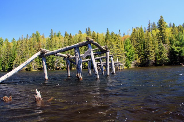 |
| Remains of old bridge across Potter Cree, north end of Canoe Lake. |
Potter Creek slowly spilled out into Canoe Lake. I had been years since I had paddled the lake
but it seemed like only yesterday. A
good wind at my back helped me down the lake as I passed the Tom Thomson
memorial point, Camp Wapomeo and the lighthouse island until the Portage Store
came into view. Several minutes later I
landed on the beach at the access point where I had started three days
ago. While the trip was challenging at
points due to the low maintenance nature of the route it was definitely a
rewarding one. My only wish was that it
could have been longer.
I was looking for pictures of Brown Lake - thank you for your blog!
ReplyDeleteHeading up to Furrow Lake tomorrow, glad I found this report. Thanks for posting.
ReplyDeleteJust found this site.. it's great. BTW, I went to Arowhon for many years, and now, many years later, took the Potter Creek portage for the first time.
ReplyDeleteI actually know no one from camp who ever took it!
It's easier to get to camp via Joe, and heading north, people go via Tom Thomson.